Delwedd:Tonga Volcano Eruption 2022-01-15 0450Z.jpg
Maint y rhagolwg: 600 × 600 picsel. Eglurdebau eraill: 240 × 240 picsel | 480 × 480 picsel | 768 × 768 picsel | 1,024 × 1,024 picsel | 2,048 × 2,048 picsel | 5,405 × 5,405 picsel.
Maint llawn ((5,405 × 5,405 picsel, maint y ffeil: 6.89 MB, ffurf MIME: image/jpeg))
Crynodeb
| Disgrifiad |
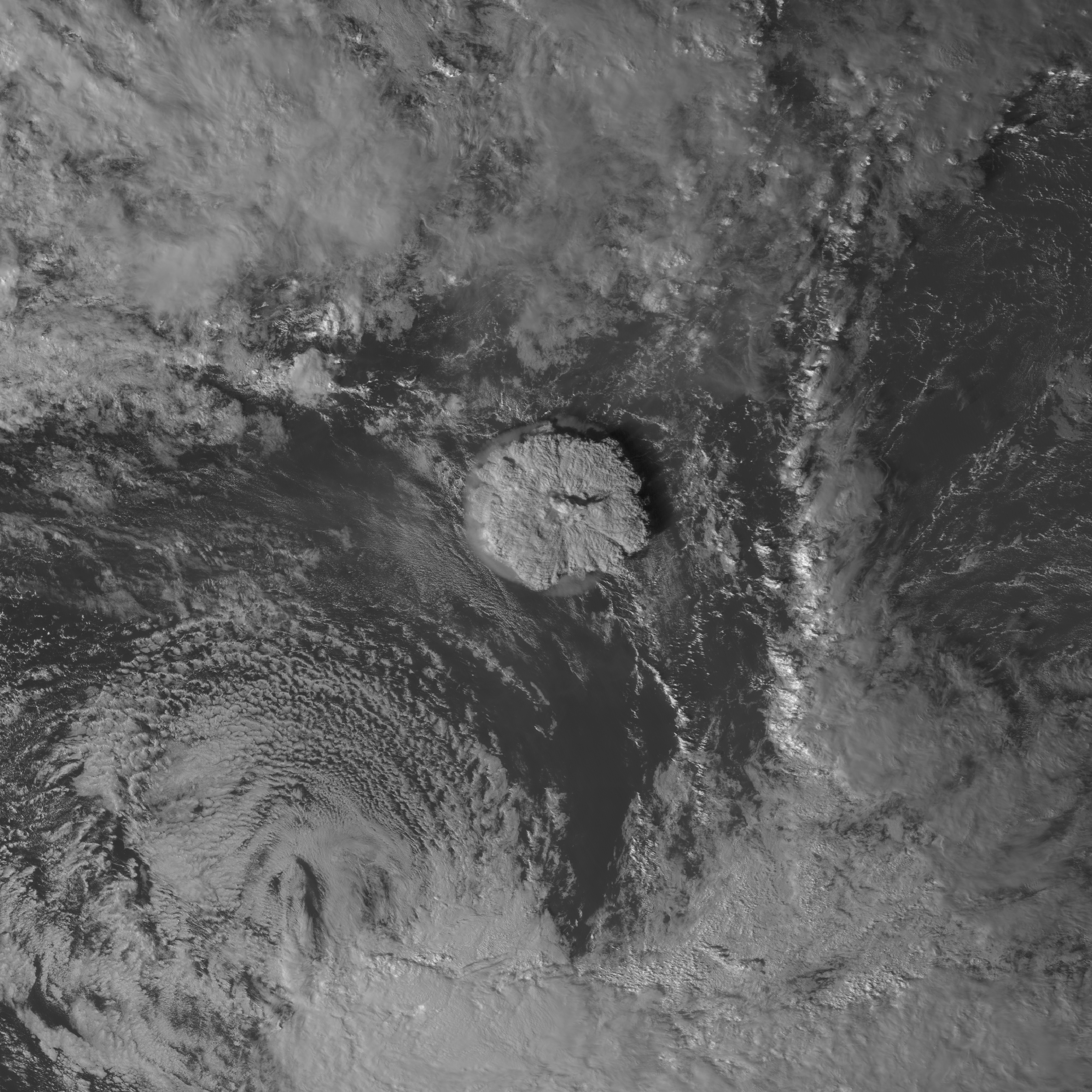
English: Taken by the Himawari 8 satellite, this red-filter visible image of a volcanic eruption in Tonga was taken on 15 January 2022 at 04:50 (UTC) 5:50 PM (Tonga Local Time). This volcanic eruption produced a 3.9 foot (1.2 meter) tsunami which struck Nukuʻalofa, the capital of Tonga. The volcano also triggered tsunamis across the Pacific Ocean affecting countries and territories like Fiji, Samoa, Wallis and Futuna, Vanuatu, New Zealand, Australia, Japan, Russia, the United States, Canada, Mexico, Chile and Ecuador, and explosions and the shockwave from the eruption could be heard as far as Alaska and Canada. Also visible in this image is the remnants of Tropical Cyclone Cody to the southwest. |
| Dyddiad | Taken on 15 Ionawr 2022, 04:50 UTC |
| Ffynhonnell | https://worldview.earthdata.nasa.gov/; direct link to image frame: https://go.nasa.gov/3nvh6HC |
| Awdur | Japan Meteorological Agency/NASA SPoRT |
| Caniatâd (Ailddefnyddio'r ffeil hon) |
http://www.jma.go.jp/jma/en/copyright.html |
Trwyddedu
This image was produced by the Japan Meteorological Agency. The legal notice (archive) stated that all the images published on their website is compatible with the Creative Commons Attribution 4.0 License, which means that all the images on this website is published under the Creative Commons Attribution 4.0 License unless otherwise specified.
Trwyddedir y ffeil hon yn ôl termau'r drwydded Creative Commons Attribution 4.0 International. Cydnabyddiaeth: Japan Meteorological Agency
|
 |

Hanes y ffeil
Cliciwch ar ddyddiad / amser i weld y ffeil fel ag yr oedd bryd hynny.
| Dyddiad / Amser | Bawdlun | Hyd a lled | Defnyddiwr | Sylw | |
|---|---|---|---|---|---|
| cyfredol | 18:54, 17 Ionawr 2022 | | 5,405 × 5,405 (6.89 MB) | Huntster | c:User:Rillke/bigChunkedUpload.js: Highest resolution allowed by Worldview. |
| 14:03, 15 Ionawr 2022 |  | 2,700 × 2,700 (2.49 MB) | TheWxResearcher | Uploaded a work by NASA (Website) JMA (Satellite) from https://worldview.earthdata.nasa.gov/ with UploadWizard |
Cysylltiadau'r ffeil
Mae'r 1 tudalennau a ddefnyddir isod yn cysylltu i'r ddelwedd hon:
Defnydd cydwici y ffeil
Mae'r wicis eraill hyn yn defnyddio'r ffeil hon:
- Y defnydd ar de.wikipedia.org
- Y defnydd ar en.wikipedia.org
- Y defnydd ar fr.wikipedia.org
- Y defnydd ar pt.wikipedia.org
- Y defnydd ar ta.wikipedia.org