Delwedd:Wirral peninsula satellite.png
Wedi ei chwyddo hyd yr eithaf.
Wirral_peninsula_satellite.png ((400 × 400 picsel, maint y ffeil: 299 KB, ffurf MIME: image/png))
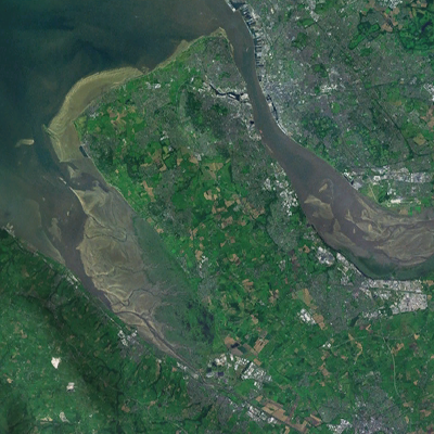
| Disgrifiad | A satellite photograph of the Wirral Peninsula (centre), showing the River Mersey and its estuary to the east, Liverpool Bay to the north and River Dee in the west across from the coast of Flintshire in Wales. |
| Dyddiad | |
| Ffynhonnell | NASA World Wind - Landsat 7 |
| Awdur | Smurrayinchester |
| This image is in the public domain because it is a screenshot from NASA’s globe software World Wind using a public domain layer, such as Blue Marble, MODIS, Landsat, SRTM, USGS or GLOBE.
|
 |
| Camera location | | View this and other nearby images on: OpenStreetMap |
|---|

Hanes y ffeil
Cliciwch ar ddyddiad / amser i weld y ffeil fel ag yr oedd bryd hynny.
| Dyddiad / Amser | Bawdlun | Hyd a lled | Defnyddiwr | Sylw | |
|---|---|---|---|---|---|
| cyfredol | 20:33, 29 Awst 2022 | | 400 × 400 (299 KB) | DankJae | File:Liverpool Bay.png cropped 69 % horizontally, 58 % vertically using CropTool with precise mode. |
Cysylltiadau'r ffeil
Mae'r 1 tudalennau a ddefnyddir isod yn cysylltu i'r ddelwedd hon:
Defnydd cydwici y ffeil
Mae'r wicis eraill hyn yn defnyddio'r ffeil hon:
- Y defnydd ar en.wikipedia.org