Delwedd:EnglishChannel.jpg

Maint y rhagolwg: 800 × 478 picsel. Eglurdebau eraill: 320 × 191 picsel | 640 × 382 picsel | 1,133 × 677 picsel.
Maint llawn ((1,133 × 677 picsel, maint y ffeil: 235 KB, ffurf MIME: image/jpeg))
Crynodeb
Español: El canal de la Mancha
Ελληνικά: Θάλασσα της Μάγχης
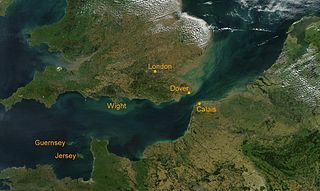
Satellite photo of the Strait of Dover (English Channel). Source: Nasa. Formatted by Stw (wikipedia.de)
| This file is in the public domain in the United States because it was solely created by NASA. NASA copyright policy states that "NASA material is not protected by copyright unless noted". (See Template:PD-USGov, NASA copyright policy page or JPL Image Use Policy.) | ||
 |
Warnings:
|
Hanes y ffeil
Cliciwch ar ddyddiad / amser i weld y ffeil fel ag yr oedd bryd hynny.
| Dyddiad / Amser | Bawdlun | Hyd a lled | Defnyddiwr | Sylw | |
|---|---|---|---|---|---|
| cyfredol | 14:16, 9 Rhagfyr 2004 | | 1,133 × 677 (235 KB) | Muriel Gottrop~commonswiki | Satellite photo of the Strait of Dover (English Channel). Source: Nasa. Formatted by Stw (wikipedia.de) {{PD}} {{Cc-by-sa}} |
Cysylltiadau'r ffeil
Nid oes tudalennau'n defnyddio'r ffeil hon.
Defnydd cydwici y ffeil
Mae'r wicis eraill hyn yn defnyddio'r ffeil hon:
- Y defnydd ar af.wikipedia.org
- Y defnydd ar an.wikipedia.org
- Y defnydd ar ar.wikipedia.org
- Y defnydd ar arz.wikipedia.org
- Y defnydd ar ast.wikipedia.org
- Y defnydd ar az.wikipedia.org
- Y defnydd ar ba.wikipedia.org
- Y defnydd ar be-tarask.wikipedia.org
- Y defnydd ar be.wikipedia.org
- Y defnydd ar bg.wikipedia.org
- Y defnydd ar bn.wikipedia.org
- Y defnydd ar bo.wikipedia.org
- Y defnydd ar br.wikipedia.org
- Y defnydd ar br.wiktionary.org
- Y defnydd ar bs.wikipedia.org
- Y defnydd ar ca.wikipedia.org
- Y defnydd ar ceb.wikipedia.org
- Y defnydd ar ce.wikipedia.org
- Y defnydd ar cs.wikipedia.org
- Y defnydd ar cv.wikipedia.org
- Y defnydd ar da.wikipedia.org
- Y defnydd ar de.wikipedia.org
- Y defnydd ar de.wikivoyage.org
- Y defnydd ar de.wiktionary.org
- Y defnydd ar diq.wikipedia.org
- Y defnydd ar en.wikipedia.org
- Y defnydd ar en.wiktionary.org
- Y defnydd ar eo.wikipedia.org
Gweld rhagor o'r defnydd cydwici o'r ffeil hon.