Delwedd:Isle of Man map-en.svg

Maint rhagolwg PNG o ffeil SVG yw: 654 × 600 picsel. Eglurdebau eraill: 262 × 240 picsel | 524 × 480 picsel | 838 × 768 picsel | 1,117 × 1,024 picsel | 2,234 × 2,048 picsel | 1,200 × 1,100 picsel.
Maint llawn (Ffeil SVG, maint mewn enw 1,200 × 1,100 picsel, maint y ffeil: 686 KB)

Crynodeb
| Disgrifiad |
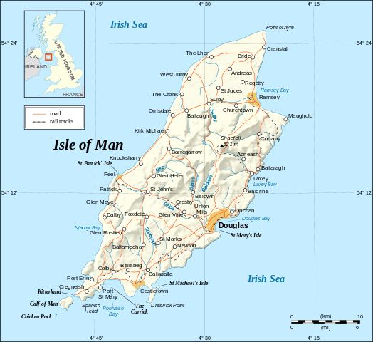
English: Map in English of the Isle of Man.
Note : The shaded relief is a raster image embedded in the SVG. Français : Carte en anglais de l'Île de Man. Note : Le relief ombré est une image bitmap incrustée dans le fichier SVG. UTM projection; WGS84 datum; shaded relief (composite image of N-W, W and N lightning positions); |
||
| Dyddiad | |||
| Ffynhonnell |
Own work ;
|
||
| Awdur | Eric Gaba (Sting - fr:Sting) | ||
| Caniatâd (Ailddefnyddio'r ffeil hon) |
|
||
| Diwygiadau eraill |
[]
|


|
This SVG file contains embedded text that can be translated into your language, using any capable SVG editor, text editor or the SVG Translate tool. For more information see: About translating SVG files. |
Trwyddedu
Yr wyf fi, deiliad yr hawlfraint ar y gwaith hwn, yn ei gyhoeddi yn ôl termau'r trwyddedau a ganlyn:

|
Caniateir copïo, dosbarthu a/neu golygu'r ddogfen hon yn ôl telerau'r Drwydded Ddogfennaeth Rydd GNU, Fersiwn 1.2 neu unrhyw fersiwn diweddarach a gyhoeddwyd gan y Free Software Foundation; yn cynnwys dim Adrannau Di-syfl, dim Testunau Clawr Blaen, a dim Testunau Clawr Cefn. Cynhwysir copi o'r drwydded hon yn yr adran Trwydded Ddogfennaeth Rydd GNU". |
| Trwyddedir y ffeil hon yn ôl termau'r drwydded Creative Commons Attribution-Share Alike 3.0 Unported. | ||
| ||
| Ychwangwyd y nod trwyddedu hwn wrth y ffeil hon yn ran o'r gwaith o ddiweddaru trwyddedau GFDL. |
Trwyddedir y ffeil hon yn ôl termau'r drwydded Creative Commons Attribution-Share Alike 2.5 Generic, 2.0 Generic a 1.0 Generic.
- Mae'n rhydd i chi:
- rhannu – gallwch gopïo, dosbarthu a throsglwyddo'r gwaith
- ailwampio – gallwch addasu'r gwaith
- Ar yr amodau canlynol:
- cydnabyddiaeth – Mae'n rhaid i chi nodi manylion y gwaith hwn, rhoi dolen i'r drwydded, a nodi os y bu golygu arni, yn y modd a benwyd gan yr awdur neu'r trwyddedwr (ond heb awgrymu o gwbl eu bod yn eich cymeradwyo chi na'ch defnydd o'r gwaith).
- rhannu ar dermau tebyg – Os byddwch yn addasu'r gwaith hwn, neu yn ei drawsnewid, neu yn adeiladu arno, mae'n rhaid i chi ddosbarthu'r gwaith dan drwydded sy'n union yr un fath same a'r gwreiddiol.
Gallwch ddewis y drwydded y mynnwch.
Hanes y ffeil
Cliciwch ar ddyddiad / amser i weld y ffeil fel ag yr oedd bryd hynny.
| Dyddiad / Amser | Bawdlun | Hyd a lled | Defnyddiwr | Sylw | |
|---|---|---|---|---|---|
| cyfredol | 14:38, 4 Medi 2008 | | 1,200 × 1,100 (686 KB) | Sting | New standard colors |
| 23:03, 21 Mai 2007 |  | 1,200 × 1,100 (786 KB) | Sting | {{Information |Description=Map in English of the Isle of Man |Source=Own work ;<br/>Background map and shaded relief : [http://www2.jpl.nasa.gov/srtm NASA Shuttle Radar Topography Mission] (SRTM3 v.2) (public domain) edited with [http: |
Cysylltiadau'r ffeil
Mae'r 1 tudalennau a ddefnyddir isod yn cysylltu i'r ddelwedd hon:
Defnydd cydwici y ffeil
Mae'r wicis eraill hyn yn defnyddio'r ffeil hon:
- Y defnydd ar ca.wikipedia.org
- Y defnydd ar cv.wikipedia.org
- Y defnydd ar de.wikipedia.org
- Y defnydd ar en.wikipedia.org
- Y defnydd ar en.wikibooks.org
- Y defnydd ar en.wikisource.org
- Y defnydd ar eo.wikipedia.org
- Y defnydd ar es.wikipedia.org
- Y defnydd ar es.wiktionary.org
- Y defnydd ar fa.wikipedia.org
- Y defnydd ar frr.wikipedia.org
- Y defnydd ar gag.wikipedia.org
- Y defnydd ar ga.wikipedia.org
- Y defnydd ar gv.wikipedia.org
- Y defnydd ar ha.wikipedia.org
- Y defnydd ar hr.wikipedia.org
- Y defnydd ar ja.wikipedia.org
- Y defnydd ar kw.wikipedia.org
- Y defnydd ar lt.wikipedia.org
- Y defnydd ar mi.wikipedia.org
- Y defnydd ar mr.wikipedia.org
- Y defnydd ar nl.wikipedia.org
- Y defnydd ar ps.wikipedia.org
- Y defnydd ar sk.wikipedia.org
- Y defnydd ar sl.wikipedia.org
- Y defnydd ar stq.wikipedia.org
- Y defnydd ar tr.wikipedia.org
- Y defnydd ar tr.wiktionary.org
- Y defnydd ar vi.wikipedia.org
- Y defnydd ar vls.wikipedia.org
- Y defnydd ar zh.wikipedia.org