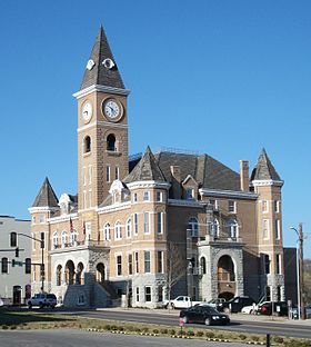
Washington County, Arkansas
Sir yn nhalaith Arkansas, Unol Daleithiau America yw Washington County. Sefydlwyd Washington County, Arkansas ym 1828 a sedd weinyddol y sir (a elwir weithiau'n 'dref sirol' neu'n 'brifddinas y sir') yw Fayetteville.
 | |
| Math | sir |
|---|---|
| Prifddinas | Fayetteville |
| Poblogaeth | 245,871 |
| Sefydlwyd | |
| Daearyddiaeth | |
| Gwlad | |
| Arwynebedd | 2,476 km² |
| Talaith | Arkansas |
| Yn ffinio gyda | Benton County, Madison County, Crawford County, Adair County |
| Cyfesurynnau | 36.0025°N 94.2272°W |
 | |
Mae ganddi arwynebedd o 2,476 cilometr sgwâr. Allan o'r arwynebedd hwn, y canran o ffurfiau dyfrol, megis llynnoedd ac afonydd, yw 0.6% . Yn ôl cyfrifiad y wlad, poblogaeth y sir yw: 245,871 (1 Ebrill 2020)[1]. Mewn cymhariaeth, yn 2016 roedd poblogaeth Caerdydd yn 361,462 a Rhyl tua 26,000.[2]
Mae'n ffinio gyda Benton County, Madison County, Crawford County, Adair County.
 |
|
| Map o leoliad y sir o fewn Arkansas |
Lleoliad Arkansas o fewn UDA |
Ceir sawl sir o’r un enw gan gynnwys:
- Washington County, Alabama
- Washington County, Arkansas
- Washington County, Colorado
- Washington County, Efrog Newydd
- Washington County, Florida
- Washington County, Georgia
- Washington County, Gogledd Carolina
- Washington County, Idaho
- Washington County, Illinois
- Washington County, Indiana
- Washington County, Iowa
- Washington County, Kansas
- Washington County, Kentucky
- Washington County, Maine
- Washington County, Maryland
- Washington County, Minnesota
- Washington County, Mississippi
Trefi mwyaf
golyguMae gan y sir yma boblogaeth o tua 245,871 (1 Ebrill 2020)[1]. Dyma rai o'r dinasoedd, trefi neu gymunedau mwyaf poblog y sir:
Rhestr Wicidata:
| Tref neu gymuned | Poblogaeth | Arwynebedd |
|---|---|---|
| Fayetteville | 93949[3][4] | 143.490443[5] |
| Springdale | 84161[4] | 121.594206[5] 108.935574[6] |
| Farmington | 7584[4] | 25.587868[5] 25.584712[6] |
| Prairie Grove | 7045[4] | 24.177486[5] 20.854142[6] |
| Tontitown | 4301[4] | 47.084355[5] 47.275443[6] |
| West Fork Township | 3681[4] | |
| Johnson | 3609[4] | 9.393502[5] 9.823553[6] |
| Elkins | 3602[4] | 10.302583[5] 10.302581[6] |
| West Fork | 2331[4] | 9.847459[5] 9.848054[7] |
| Lincoln | 2294[4] | 7.174769[5] 7.174772[6] |
| Goshen | 2102[4] | 30.295612[5] 30.295568[6] |
| Greenland | 1213[4] | 9.214979[5] 7.622138[6] |
| Winslow | 365[4] | 4.9425[5] 4.942497[6] |
| Cincinnati | 306[4] | |
| Morrow | 263[4] |
Cyfeiriadau
golygu- ↑ 1.0 1.1 https://data.census.gov/cedsci/table?t=Populations%20and%20People&g=0100000US,%241600000&y=2020. Cyfrifiad yr Unol Daleithiau 2020. golygydd: Biwro Cyfrifiad yr Unol Daleithiau. dyddiad cyrchiad: 1 Ionawr 2022.
- ↑ statswales.gov.wales; adalwyd 25 Mawrth 2020.
- ↑ https://data.census.gov/cedsci/table?q=United%20States&tid=DECENNIALPL2020.P1
- ↑ 4.00 4.01 4.02 4.03 4.04 4.05 4.06 4.07 4.08 4.09 4.10 4.11 4.12 4.13 4.14 https://data.census.gov/cedsci/table?t=Populations%20and%20People&g=0100000US,%241600000&y=2020
- ↑ 5.00 5.01 5.02 5.03 5.04 5.05 5.06 5.07 5.08 5.09 5.10 5.11 2016 U.S. Gazetteer Files
- ↑ 6.00 6.01 6.02 6.03 6.04 6.05 6.06 6.07 6.08 6.09 2010 U.S. Gazetteer Files
- ↑ https://www.census.gov/geographies/reference-files/time-series/geo/gazetteer-files.2010.html
