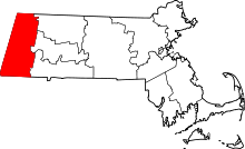
Berkshire County, Massachusetts
Sir yn nhalaith Massachusetts[1], Unol Daleithiau America yw Berkshire County. Cafodd ei henwi ar ôl Berkshire. Sefydlwyd Berkshire County, Massachusetts ym 1761 a sedd weinyddol y sir (a elwir weithiau'n 'dref sirol' neu'n 'brifddinas y sir') yw Pittsfield.
 | |
| Math | un o siroedd Massachusetts |
|---|---|
| Enwyd ar ôl | Berkshire |
| Prifddinas | Pittsfield |
| Poblogaeth | 129,026 |
| Sefydlwyd | |
| Daearyddiaeth | |
| Gwlad | |
| Arwynebedd | 2,451 km² |
| Talaith | Massachusetts[1] |
| Yn ffinio gyda | Bennington County, Franklin County, Hampshire County, Hampden County, Litchfield County, Dutchess County, Columbia County, Rensselaer County, Northwest Hills Planning Region |
| Cyfesurynnau | 42.39613°N 73.209892°W |
 | |
Mae ganddi arwynebedd o 2,451 cilometr sgwâr. Allan o'r arwynebedd hwn, y canran o ffurfiau dyfrol, megis llynnoedd ac afonydd, yw 2.1% . Yn ôl cyfrifiad y wlad, poblogaeth y sir yw: 129,026 (1 Ebrill 2020)[2][3]. Mewn cymhariaeth, yn 2016 roedd poblogaeth Caerdydd yn 361,462 a Rhyl tua 26,000.[4]
Mae'n ffinio gyda Bennington County, Franklin County, Hampshire County, Hampden County, Litchfield County, Dutchess County, Columbia County, Rensselaer County, Northwest Hills Planning Region. Cedwir rhestr swyddogol o henebion ac adeiladau cofrestredig y sir yn: National Register of Historic Places listings in Berkshire County, Massachusetts.
 |
|
| Map o leoliad y sir o fewn Massachusetts[1] |
Lleoliad Massachusetts[1] o fewn UDA |
Trefi mwyaf
golyguMae gan y sir yma boblogaeth o tua 129,026 (1 Ebrill 2020)[2][3]. Dyma rai o'r dinasoedd, trefi neu gymunedau mwyaf poblog y sir:
Rhestr Wicidata:
| Tref neu gymuned | Poblogaeth | Arwynebedd |
|---|---|---|
| Pittsfield | 43927[5] | 109.977605[6] 109.984277[7] |
| North Adams | 12961[5] | 53.389969[6] |
| Adams | 8166[5] | 59.5 |
| Williamstown | 7513[5] | 121400000 |
| Great Barrington | 7172[5] | 118.4 |
| Dalton | 6330[5] | 56.7 |
| Lee | 5788[5] | 70 |
| Adams | 5466[5] | 5.925673[6] 5.925675[7] |
| Lenox | 5095[5] | 56.1 |
| Williamstown | 4308[5] | 8.875148[6] 8.875175[7] |
| Sheffield | 3327[5] | 125.8 |
| Cheshire | 3258[5] | 71.3 |
| Lanesborough | 3038[5] | 76.6 |
| Great Barrington | 2234[5] | 3.65097[6] 3.650968[7] 3.650968 |
| Stockbridge | 2018[5] | 61.3 |
Cyfeiriadau
golygu- ↑ 1.0 1.1 1.2 1.3 1.4 http://quickfacts.census.gov/qfd/states/25/25003lk.html. Biwro Cyfrifiad yr Unol Daleithiau. dyddiad cyrchiad: 10 Gorffennaf 2015.
- ↑ 2.0 2.1 https://data.census.gov/cedsci/table?t=Populations%20and%20People&g=0100000US,%241600000&y=2020. Cyfrifiad yr Unol Daleithiau 2020. golygydd: Biwro Cyfrifiad yr Unol Daleithiau. dyddiad cyrchiad: 1 Ionawr 2022.
- ↑ 3.0 3.1 https://data.census.gov/cedsci/table?t=Populations%20and%20People&g=0100000US,%241600000&y=2020. Cyfrifiad yr Unol Daleithiau 2020. golygydd: Biwro Cyfrifiad yr Unol Daleithiau. dyddiad cyrchiad: 1 Ebrill 2022.
- ↑ statswales.gov.wales; adalwyd 25 Mawrth 2020.
- ↑ 5.00 5.01 5.02 5.03 5.04 5.05 5.06 5.07 5.08 5.09 5.10 5.11 5.12 5.13 5.14 https://data.census.gov/cedsci/table?t=Populations%20and%20People&g=0100000US,%241600000&y=2020
- ↑ 6.0 6.1 6.2 6.3 6.4 2016 U.S. Gazetteer Files
- ↑ 7.0 7.1 7.2 7.3 2010 U.S. Gazetteer Files
