Columbia County, Georgia
Sir yn nhalaith Georgia, Unol Daleithiau America yw Columbia County. Cafodd ei henwi ar ôl Christopher Columbus[1]. Sefydlwyd Columbia County, Georgia ym 1790 a sedd weinyddol y sir (a elwir weithiau'n 'dref sirol' neu'n 'brifddinas y sir') yw Appling.
 | |
| Math | sir |
|---|---|
| Enwyd ar ôl | Christopher Columbus |
| Prifddinas | Appling |
| Poblogaeth | 156,010 |
| Sefydlwyd | |
| Daearyddiaeth | |
| Gwlad | |
| Arwynebedd | 797 km² |
| Talaith | Georgia |
| Yn ffinio gyda | Lincoln County, McCormick County, Edgefield County, Richmond County, McDuffie County |
| Cyfesurynnau | 33.55°N 82.26°W |
 | |
Mae ganddi arwynebedd o 797 cilometr sgwâr. Allan o'r arwynebedd hwn, y canran o ffurfiau dyfrol, megis llynnoedd ac afonydd, yw 5.7% . Yn ôl cyfrifiad y wlad, poblogaeth y sir yw: 156,010 (1 Ebrill 2020)[2]. Mewn cymhariaeth, yn 2016 roedd poblogaeth Caerdydd yn 361,462 a Rhyl tua 26,000.[3]
Mae'n ffinio gyda Lincoln County, McCormick County, Edgefield County, Richmond County, McDuffie County. Cedwir rhestr swyddogol o henebion ac adeiladau cofrestredig y sir yn: National Register of Historic Places listings in Columbia County, Georgia.
 |
|
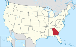
| Map o leoliad y sir o fewn Georgia |
Lleoliad Georgia o fewn UDA |
Ceir sawl sir o’r un enw gan gynnwys:
- Columbia County, Arkansas
- Columbia County, Efrog Newydd
- Columbia County, Florida
- Columbia County, Georgia
- Columbia County, Oregon
- Columbia County, Pennsylvania
- Columbia County, Washington
- Columbia County, Wisconsin
Trefi mwyaf
golyguMae gan y sir yma boblogaeth o tua 156,010 (1 Ebrill 2020)[2]. Dyma rai o'r dinasoedd, trefi neu gymunedau mwyaf poblog y sir:
Rhestr Wicidata:
| Tref neu gymuned | Poblogaeth | Arwynebedd |
|---|---|---|
| Evans | 34536[4] | 68.790656[5] 68.794007[6] |
| Martinez | 34535[4] | 37.843668[5] 37.871202[7] |
| Grovetown | 15577[4] | 13.74711[5] 12.518619[7] |
| Harlem | 3571[4] | 11750000 11.749684[7] |
| Appling | 658[4] |
Cyfeiriadau
golygu- ↑ http://www.kenkrakow.com/gpn/c.pdf. dyfyniad: COLUMBIA COUNTY. Created December 10,1790 with 290 square miles taken from Richmond County. Named for the great navigator and discoverer of the Western Hemisphere, Christopher Columbus (c. 1446-1506)..
- ↑ 2.0 2.1 https://data.census.gov/cedsci/table?t=Populations%20and%20People&g=0100000US,%241600000&y=2020. Cyfrifiad yr Unol Daleithiau 2020. golygydd: Biwro Cyfrifiad yr Unol Daleithiau. dyddiad cyrchiad: 1 Ionawr 2022.
- ↑ statswales.gov.wales; adalwyd 25 Mawrth 2020.
- ↑ 4.0 4.1 4.2 4.3 4.4 https://data.census.gov/cedsci/table?t=Populations%20and%20People&g=0100000US,%241600000&y=2020
- ↑ 5.0 5.1 5.2 2016 U.S. Gazetteer Files
- ↑ https://www.census.gov/geographies/reference-files/time-series/geo/gazetteer-files.2010.html
- ↑ 7.0 7.1 7.2 2010 U.S. Gazetteer Files
