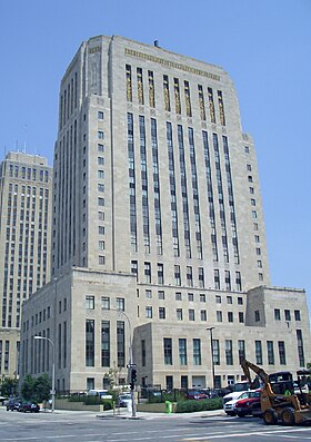
Jackson County, Missouri
Sir yn nhalaith Missouri, Unol Daleithiau America yw Jackson County. Cafodd ei henwi ar ôl Andrew Jackson. Sefydlwyd Jackson County, Missouri ym 1826 a sedd weinyddol y sir (a elwir weithiau'n 'dref sirol' neu'n 'brifddinas y sir') yw Dinas Kansas, Independence, Missouri.
 | |
| Math | sir |
|---|---|
| Enwyd ar ôl | Andrew Jackson |
| Prifddinas | Dinas Kansas, Independence, Missouri |
| Poblogaeth | 717,204 |
| Sefydlwyd | |
| Daearyddiaeth | |
| Gwlad | |
| Arwynebedd | 1,596 km² |
| Talaith | Missouri |
| Yn ffinio gyda | Clay County, Cass County, Ray County, Lafayette County, Johnson County, Johnson County, Wyandotte County |
| Cyfesurynnau | 39.01°N 94.34°W |
 | |
Mae ganddi arwynebedd o 1,596 cilometr sgwâr. Allan o'r arwynebedd hwn, y canran o ffurfiau dyfrol, megis llynnoedd ac afonydd, yw 1.9% . Yn ôl cyfrifiad y wlad, poblogaeth y sir yw: 717,204 (1 Ebrill 2020)[1]. Mewn cymhariaeth, yn 2016 roedd poblogaeth Caerdydd yn 361,462 a Rhyl tua 26,000.[2]
Mae'n ffinio gyda Clay County, Cass County, Ray County, Lafayette County, Johnson County, Johnson County, Wyandotte County. Cedwir rhestr swyddogol o henebion ac adeiladau cofrestredig y sir yn: National Register of Historic Places listings in Jackson County, Missouri.
 |
|
| Map o leoliad y sir o fewn Missouri |
Lleoliad Missouri o fewn UDA |
Ceir sawl sir o’r un enw gan gynnwys:
- Jackson County, Alabama
- Jackson County, Arkansas
- Jackson County, Colorado
- Jackson County, De Dakota
- Jackson County, Florida
- Jackson County, Georgia
- Jackson County, Gogledd Carolina
- Jackson County, Gorllewin Virginia
- Jackson County, Illinois
- Jackson County, Indiana
- Jackson County, Iowa
- Jackson County, Kansas
- Jackson County, Kentucky
- Jackson County, Michigan
- Jackson County, Minnesota
- Jackson County, Mississippi
- Jackson County, Missouri
Trefi mwyaf
golyguMae gan y sir yma boblogaeth o tua 717,204 (1 Ebrill 2020)[1]. Dyma rai o'r dinasoedd, trefi neu gymunedau mwyaf poblog y sir:
Rhestr Wicidata:
| Tref neu gymuned | Poblogaeth | Arwynebedd |
|---|---|---|
| Dinas Kansas | 508090[3] | 826.150937[4] |
| Kaw Township | 183073[3] | 56.6 |
| Blue Township | 165925[3] | |
| Independence, Missouri | 123011[5][3] | 202.758059[4] 202.656076[6] 203.156194[7] 201.986455 1.169739 |
| Prairie Township | 111178[3] | |
| Lee's Summit, Missouri | 101108[3] | 170.532872[4] 169.35798[8] |
| Sni-A-Bar Township | 90449[3] | |
| Brooking Township | 77947[3] | |
| Washington Township | 73023[3] | |
| Blue Springs, Missouri | 58603[3] | 58.09033[4] 57.899479[8] |
| Raytown, Missouri | 30012[3] | 25.823172[4] 25.823177[8] |
| Grandview, Missouri | 26209[3] | 38.286992[4] 38.283239[8] |
| Grain Valley, Missouri | 15627[3] | 15.750651[4] 15.720542[8] |
| Van Buren Township | 8906[3] | |
| Oak Grove, Missouri | 8157[3] | 16.03 16.027774[8] |
Cyfeiriadau
golygu- ↑ 1.0 1.1 https://data.census.gov/cedsci/table?t=Populations%20and%20People&g=0100000US,%241600000&y=2020. Cyfrifiad yr Unol Daleithiau 2020. golygydd: Biwro Cyfrifiad yr Unol Daleithiau. dyddiad cyrchiad: 1 Ionawr 2022.
- ↑ statswales.gov.wales; adalwyd 25 Mawrth 2020.
- ↑ 3.00 3.01 3.02 3.03 3.04 3.05 3.06 3.07 3.08 3.09 3.10 3.11 3.12 3.13 3.14 https://data.census.gov/cedsci/table?t=Populations%20and%20People&g=0100000US,%241600000&y=2020
- ↑ 4.0 4.1 4.2 4.3 4.4 4.5 4.6 2016 U.S. Gazetteer Files
- ↑ https://data.census.gov/cedsci/profile?g=1600000US2935000
- ↑ https://www.census.gov/geographies/reference-files/time-series/geo/gazetteer-files.2010.html
- ↑ https://www.census.gov/geographies/reference-files/time-series/geo/gazetteer-files.2020.html
- ↑ 8.0 8.1 8.2 8.3 8.4 8.5 2010 U.S. Gazetteer Files
