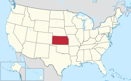
McPherson County, Kansas
Sir yn nhalaith Kansas, Unol Daleithiau America yw McPherson County. Cafodd ei henwi ar ôl James B. McPherson. Sefydlwyd McPherson County, Kansas ym 1867 a sedd weinyddol y sir (a elwir weithiau'n 'dref sirol' neu'n 'brifddinas y sir') yw McPherson.
 | |
| Math | sir |
|---|---|
| Enwyd ar ôl | James B. McPherson |
| Prifddinas | McPherson |
| Poblogaeth | 30,223 |
| Sefydlwyd | |
| Cylchfa amser | Cylchfa Amser Canolog |
| Daearyddiaeth | |
| Gwlad | |
| Arwynebedd | 2,334 km² |
| Talaith | Kansas |
| Yn ffinio gyda | Saline County, Dickinson County, Marion County, Harvey County, Reno County, Rice County, Ellsworth County |
| Cyfesurynnau | 38.4°N 97.7°W |
 | |
Mae ganddi arwynebedd o 2,334 cilometr sgwâr. Allan o'r arwynebedd hwn, y canran o ffurfiau dyfrol, megis llynnoedd ac afonydd, yw 0.3% . Yn ôl cyfrifiad y wlad, poblogaeth y sir yw: 30,223 (1 Ebrill 2020)[1]. Mewn cymhariaeth, yn 2016 roedd poblogaeth Caerdydd yn 361,462 a Rhyl tua 26,000.[2]
Mae'n ffinio gyda Saline County, Dickinson County, Marion County, Harvey County, Reno County, Rice County, Ellsworth County. Ceir 9 cylchfa amser yn UDA, ac mae'r sir hon yn perthyn i'r cylchfa amser a elwir yn Cylchfa Amser Canolog. Cedwir rhestr swyddogol o henebion ac adeiladau cofrestredig y sir yn: National Register of Historic Places listings in McPherson County, Kansas.
 |
|
| Map o leoliad y sir o fewn Kansas |
Lleoliad Kansas o fewn UDA |
Ceir sawl sir o’r un enw gan gynnwys:
Trefi mwyaf
golyguMae gan y sir yma boblogaeth o tua 30,223 (1 Ebrill 2020)[1]. Dyma rai o'r dinasoedd, trefi neu gymunedau mwyaf poblog y sir:
Rhestr Wicidata:
| Tref neu gymuned | Poblogaeth | Arwynebedd |
|---|---|---|
| McPherson | 14082[3] | 19.636033[4] 18.720501[5] |
| Lindsborg | 3776[3] | 4380000 4.353139[6] |
| Mound Township | 2326[3] | |
| Moundridge | 1974[3] | 3.662669[4] 3.662666[5] |
| Superior Township | 1681[3] | |
| Inman | 1341[3] | 1.627744[4] 1.515654[5] |
| Empire Township | 1253[3] | |
| Canton Township | 976[3] | |
| Galva | 834[3] | 1.273297[4] 1.243452[5] |
| Marquette Township | 733[3] | |
| Canton | 685[3] | 1.300033[4] 1.300036[5] |
| Marquette | 599[3] | 1.238488[4] 1.134321[5] |
| McPherson Township | 530[3] | |
| King City Township | 506[3] | |
| Lone Tree Township | 467[3] |
Cyfeiriadau
golygu- ↑ 1.0 1.1 https://data.census.gov/cedsci/table?t=Populations%20and%20People&g=0100000US,%241600000&y=2020. Cyfrifiad yr Unol Daleithiau 2020. golygydd: Biwro Cyfrifiad yr Unol Daleithiau. dyddiad cyrchiad: 1 Ionawr 2022.
- ↑ statswales.gov.wales; adalwyd 25 Mawrth 2020.
- ↑ 3.00 3.01 3.02 3.03 3.04 3.05 3.06 3.07 3.08 3.09 3.10 3.11 3.12 3.13 3.14 https://data.census.gov/cedsci/table?t=Populations%20and%20People&g=0100000US,%241600000&y=2020
- ↑ 4.0 4.1 4.2 4.3 4.4 4.5 2016 U.S. Gazetteer Files
- ↑ 5.0 5.1 5.2 5.3 5.4 5.5 2010 U.S. Gazetteer Files
- ↑ https://www.census.gov/geographies/reference-files/time-series/geo/gazetteer-files.2010.html
