Pennington County, De Dakota
Sir yn nhalaith De Dakota, Unol Daleithiau America yw Pennington County, Mount Rushmore. Cafodd ei henwi ar ôl John L. Pennington. Sefydlwyd Pennington County, De Dakota ym 1875 a sedd weinyddol y sir (a elwir weithiau'n 'dref sirol' neu'n 'brifddinas y sir') yw Rapid City.
 | |
| Math | sir |
|---|---|
| Enwyd ar ôl | John L. Pennington |
| Prifddinas | Rapid City |
| Poblogaeth | 109,222 |
| Sefydlwyd | |
| Daearyddiaeth | |
| Gwlad | |
| Arwynebedd | 7,211 km² |
| Talaith | De Dakota |
| Yn ffinio gyda | Meade County, Custer County, Sir Oglala Lakota, Jackson County, Haakon County, Ziebach County, Lawrence County, Weston County |
| Cyfesurynnau | 44.01°N 102.82°W |
 | |
Mae ganddi arwynebedd o 7,211 cilometr sgwâr. Allan o'r arwynebedd hwn, y canran o ffurfiau dyfrol, megis llynnoedd ac afonydd, yw 0.3% . Yn ôl cyfrifiad y wlad, poblogaeth y sir yw: 109,222 (1 Ebrill 2020)[1]. Mewn cymhariaeth, yn 2016 roedd poblogaeth Caerdydd yn 361,462 a Rhyl tua 26,000.[2]
Mae'n ffinio gyda Meade County, Custer County, Sir Oglala Lakota, Jackson County, Haakon County, Ziebach County, Lawrence County, Weston County. Cedwir rhestr swyddogol o henebion ac adeiladau cofrestredig y sir yn: National Register of Historic Places listings in Pennington County, South Dakota.
 |
|
| Map o leoliad y sir o fewn De Dakota |
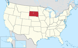
Lleoliad De Dakota o fewn UDA |
Ceir sawl sir o’r un enw gan gynnwys:
Trefi mwyaf
golyguMae gan y sir yma boblogaeth o tua 109,222 (1 Ebrill 2020)[1]. Dyma rai o'r dinasoedd, trefi neu gymunedau mwyaf poblog y sir:
Rhestr Wicidata:
| Tref neu gymuned | Poblogaeth | Arwynebedd |
|---|---|---|
| Rapid City | 74703[3][4] | 141.216229[5] 143.708071[6] 141.831516[7] 141.671579 0.159937 |
| Box Elder | 11746[4] | 36.353898[5] 36.040743[6] |
| Rapid Valley | 8098[4] | 17.026361[5] 19.280275[6] |
| Colonial Pine Hills | 1903[4] | 40.717925[5] 41.149682[6] |
| Green Valley | 1051[4] | 9.923201[5] 9.932746[8] |
| Hill City | 872[4] | 3.275939[5] 3.278052[6] |
| Wall | 699[4] | 5.735303[5] 5.735301[6] |
| Ashland Heights | 678[4] | 7.56249[5] 7.568191[6] |
| Johnson Siding | 614[4] | |
| New Underwood | 590[4] | 2.604002[5][6] |
| Keystone | 240[4] | 7.407063[5] 7.407082[6] |
| Scenic | 75[4] | 134.2 |
| Wasta | 65[4] | 0.496819[5] 0.49682[6] |
| Quinn | 63[4] | 3.107315[5] 3.002005[6] |
| Fairview Township | 57[4] |
Cyfeiriadau
golygu- ↑ 1.0 1.1 https://data.census.gov/cedsci/table?t=Populations%20and%20People&g=0100000US,%241600000&y=2020. Cyfrifiad yr Unol Daleithiau 2020. golygydd: Biwro Cyfrifiad yr Unol Daleithiau. dyddiad cyrchiad: 1 Ionawr 2022.
- ↑ statswales.gov.wales; adalwyd 25 Mawrth 2020.
- ↑ https://data.census.gov/cedsci/profile?g=1600000US4652980
- ↑ 4.00 4.01 4.02 4.03 4.04 4.05 4.06 4.07 4.08 4.09 4.10 4.11 4.12 4.13 4.14 https://data.census.gov/cedsci/table?t=Populations%20and%20People&g=0100000US,%241600000&y=2020
- ↑ 5.00 5.01 5.02 5.03 5.04 5.05 5.06 5.07 5.08 5.09 5.10 5.11 2016 U.S. Gazetteer Files
- ↑ 6.00 6.01 6.02 6.03 6.04 6.05 6.06 6.07 6.08 6.09 6.10 2010 U.S. Gazetteer Files
- ↑ https://www.census.gov/geographies/reference-files/time-series/geo/gazetteer-files.2020.html
- ↑ https://www.census.gov/geographies/reference-files/time-series/geo/gazetteer-files.2010.html
